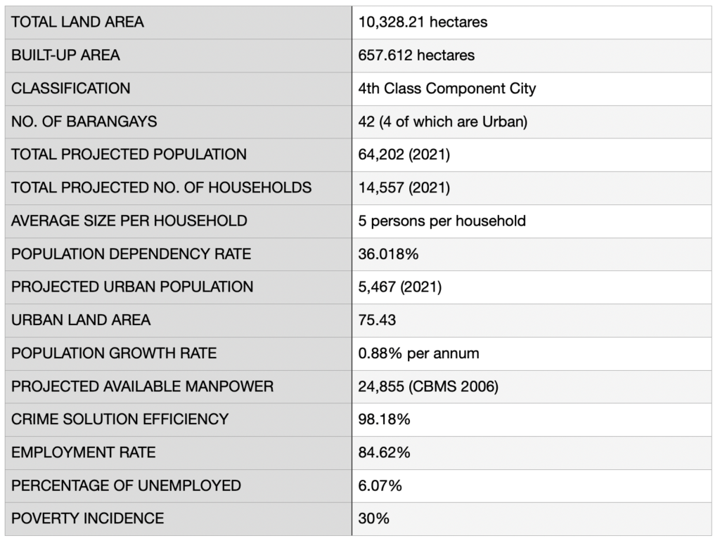
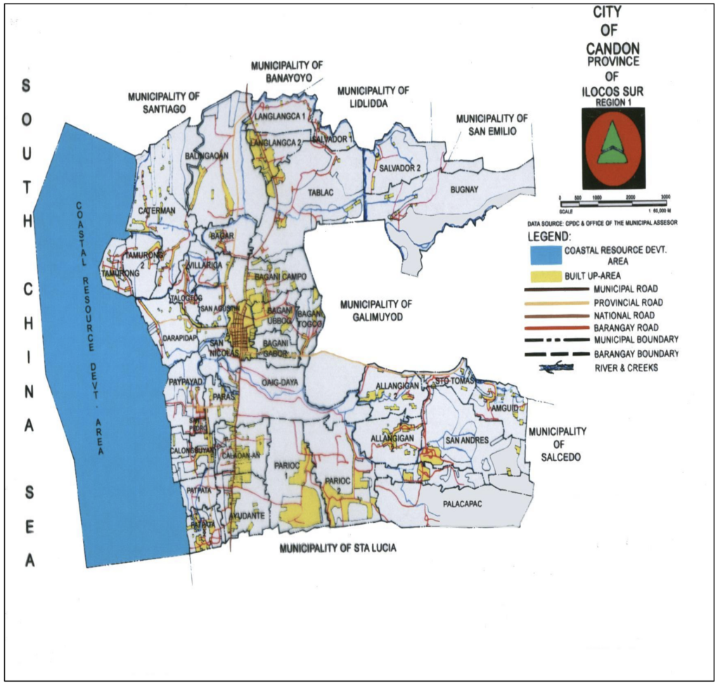
- DEMOGRAPHY
TOTAL LAND AREA = 10,328 hectares
BUILT-UP AREA = 657.612 hectares
CLASSIFICATION = 4th Class Component City
NO. OF BARANGAYS = 42 (4 of which are Urban)
TOTAL PROJECTED POPULATION = 61,505 (2013)
TOTAL PROJECTED NO. OF HOUSEHOLDS = 12,813 (2013)
AVERAGE SIZE PER HOUSEHOLD = 5 persons per household
POPULATION DEPENDENCY RATE = 36.018%
PROJECTED URBAN POPULATION = 5, 889
URBAN LAND AREA = 75.43
POPULATION GROWTH RATE = 1.49% per annum
PROJECTED AVAILABLE MANPOWER = 24,855 (CBMS 2006)
CRIME SOLUTION EFFICIENCY = 98.18%
EMPLOYMENT RATE = 84.62%
PERCENTAGE OF UNEMPLOYED = 15.38%
POVERTY INCIDENCE = 30%
- CITY STRUCTURE MAP
BOUNDARIES:
North = Municipality of Santiago, Banayoyo, Lidlidda and San Emilio
South = Municipality of Sta. Lucia
East = Municipalities of Galimuyod and Saldedo
West = South China Sea
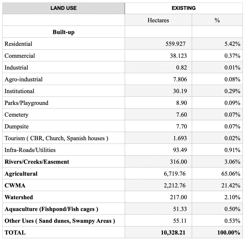
EXISTING LAND USE (General)
LAND USE EXISTING Hectares % Built-up Residential 559.927 5.42% Commercial 38.123 0.37% Industrial 0.82 0.01% Agro-industrial 7.806 0.08% Institutional 30.19 0.29% Parks/Playground 8.90 0.09% Cemetery 7.60 0.07% Dumpsite 7.70 0.07% Tourism ( CBR,Church,Spanish houses ) 1.693 0.02% Infra-Roads/Utilities 93.49 0.91% Rivers/Creeks/Easement 316.00 3.06% Agricultural 6,719.76 65.06% CWMA 2,212.76 21.42% Watershed 217.00 2.10% Aquaculture (Fishpond/Fishcages ) 51.33 0.50% Other Uses ( Sand dunes, Swampy Areas ) 55.11 0.53% TOTAL 10,328.21 100.00% - MAJOR NATURAL RESOURCES
AGRICULTURAL CROPS = acacia, mahogany and various fruit tree plantations, tobacco, rice, corn, cotton, string beans, onions, and coconut.
FISHERIES = Bangus and Tilapia fish nurseries and commercial ponds in the eastern coastal shores.
FORESTRY = The City of Candon has no Public Forests that it can cultivate or conserve, however, Candon City has a communal forest located in the neighboring town of San Emilio consisting of more or less 800 hectares.
TRANSPORT/ROAD NETWORKS- National Highway (12 kms.)
- 9 Provincial Roads (19.37 kms.)
- 21 City Streets (8.535 Kms.)
- Several inland Barangay Roads (161.05 kms.)
- RESOURCES AND POTENTIALS
- AGRICULTURE comprises cash crops that include tobacco, rice, corn, cotton, coconut, peanuts, beans and vegetables, and even aquaculture (fisheries) and sericulture (silkworms).
- AVAILABLE MARKETS AND PORTS are accessible in nearby Laoag City (132 kms.), the City of San Fernando, La Union (72 kms.), Baguio City (110 kms.), Abra (61 kms.) And Manila (347 kms.).
- HUMAN RESOURCES in general have a Literacy rate of 97.84% based on 2006 CBMS.
- ROLE OF THE CITY as gateway and “Bagsakan” center to 15 adjacent and outlying towns, the city offers Recreational Facilities (malls, and billiards centers, etc.), Education (with 4 universities and colleges and 2 technical/vocational institutions), Communication (with offices of Digitel, RCPI, Globe and Smart Telecenters), Transportation (with all the major buses plying through the 12 km. stretch of the National Highway), Banking (with 11 commercial and cooperative banks), Fire protection (BFP-Candon) and other government institutions such as GSIS, BIR, COA, DAR and PHILHEALTH and 4 food chains (McDONALDS, Jollibee, Greenwich, Red Ribbon, Chowking and Max restaurant. Stern Mall which houses CSI Department Store and Supermarket, cinema, GOLDILOCKS and many other stalls and the City Terminal.
- FRUITS OF CITYHOOD